What is the I-95 Corridor Mobility Planning Project?
|
I-95 is the backbone of Southeast Florida's transportation system and a critical resource for the region's economic vitality as a component of Florida's Strategic Intermodal System (SIS). But I-95 is failing to provide reliable transportation because of daily congestion, crashes, and unexpected delays. Congestion on I-95 is not just a daily challenge; it is a symptom of broader mobility and land use issues.
For Southeast Florida to continue to grow and thrive, its residents, employees, and visitors need reliable access to destinations to meet daily and other needs without overreliance on I-95 and auto travel. Also, freight travel within and through the region needs to be efficient and reliable. A system-oriented, integrated approach to transportation and land use planning is needed to deliver the economic prosperity and connected, livable communities with expanded travel choices desired in the region. |
|
Through a Working Group of local governments and stakeholder agencies, the I-95 Corridor Mobility Planning Project addresses congestion on I-95 and broader mobility and land use issues in eastern Broward and southeastern Palm Beach counties in a holistic way.
Project Area and History
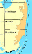
The project area extends from Florida's Turnpike and State Road 7 east to the Atlantic Ocean and from the Miami-Dade County line to the northern city limits of Boca Raton, reflecting the origins and destinations of trips using I-95.
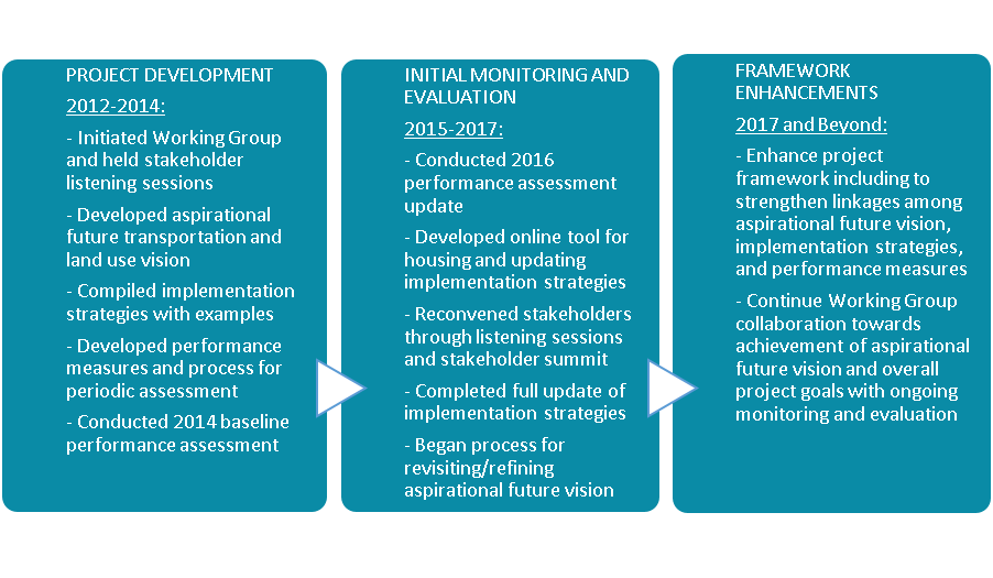
The I-95 Corridor Mobility Planning Project began with project development, continued with initial monitoring and evaluation, and will continue to evolve over time.
The I-95 Corridor Mobility Planning Project began with project development, continued with initial monitoring and evaluation, and will continue to evolve over time.
Key Project Components: Vision, Strategies, and Measures
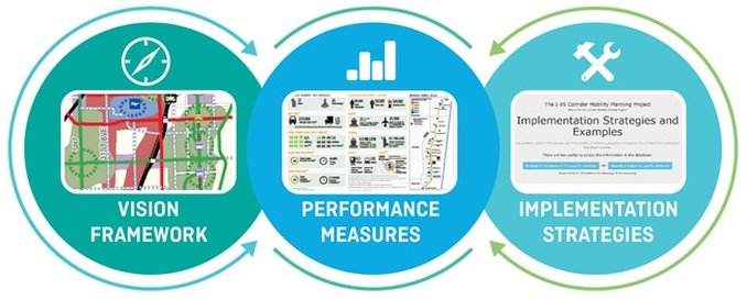
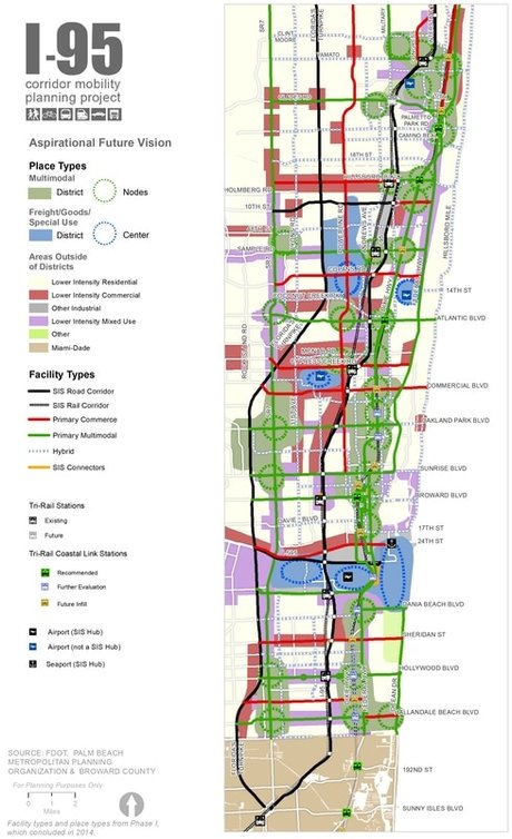
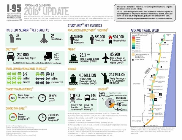
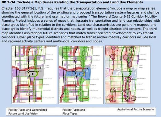
The aspirational future vision map reflects stakeholders’ transportation and land use visions and plans through a framework of facility types and place types. The implementation strategies demonstrate the variety of initiatives stakeholders are undertaking in pursuit of the vision. The performance measures monitor progress towards the vision in comparison with desired trends.
The I-95 Corridor Mobility Planning Project was highlighted in an 8-minute presentation
at the 2015 APA Florida Conference.
at the 2015 APA Florida Conference.
Stakeholder Working Group
Participating StakeholdersCities
|
The I-95 Corridor Mobility Planning Project is a collaborative process driven by a large Working Group of local government and agency stakeholders.
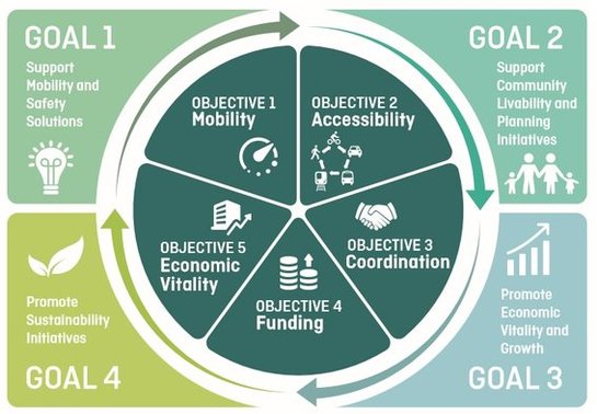
The Working Group convened several times as the project was developed, affirmed the vision map, identified strategies, and reviewed the baseline performance assessment results. Stakeholders participated in listening sessions and a stakeholder summit in October 2016 (see the Meetings page for more information). The Working Group will convene again in 2017 to move forward with next steps. Interested in getting involved? Contact us. Goals and ObjectivesThe I-95 Corridor Mobility Planning Project is guided by four goals and five objectives. The four overarching goals serve as the underlying foundation for the project. Using the four goals as a starting concept, the Working Group brainstormed project objectives that reflected the full range of desired project outcomes. The project team refined the objectives into a set of five that form the basic structural framework of the Implementation Strategies, and further describe the multi-faceted nature of the project.
|
Monitoring and Evaluation
The project is as much about process, i.e., keeping the conversation among stakeholders going and monitoring progress - as it is about substance. The project's ongoing monitoring and evaluation phase involves periodically:
- Updating the performance assessment
- Developing a status report
- Reconvening the stakeholders
- Updating the implementation strategies and examples
- Identifying continuing and new priorities.
What's New?
I-95 CMPP: Implementation Strategies Update Completed
Thanks to the robust participation of all stakeholders, the full database of implementation strategies and examples has been updated with more information on each example’s status, context, and contact information! The 100+ strategies and almost 500 examples now in the database reflect stakeholder initiatives that are collectively working towards the aspirational future vision.
This compendium is a resource with information on the wide variety of stakeholder initiatives including construction projects, transit investments, multimodal infrastructure upgrades, land use and development activities, funding initiatives, multi-jurisdiction partnerships, visioning efforts, master planning activities, freight initiatives, and many others!
Check out the updated online strategies database and browse the wealth of information now available! Note: the database may take several minutes to load.
Also, check out the Report on Stakeholder Implementation Strategies Update, September 2017, which captures stakeholder feedback and includes sections on ‘Lessons Learned’ and “Recommendations and Next Steps.’ The wide variety of stakeholder initiatives can be gleaned quickly by skimming the ‘Updated Example’ column in the Appendix A table (Full Implementation Strategies Database).
FDOT: 2045 SIS Multimodal Unfunded Needs Plan Released
The Strategic Intermodal System (SIS) Multimodal Unfunded Needs Plan (MMUNP) is the first step in FDOT’s process to plan, program, and implement transportation projects on the SIS, ensuring the state’s limited transportation funds are invested in the most efficient and effective manner. The SIS MMUMP identifies aviation, highway, rail, seaport, spaceport, and transit projects on the SIS that would help meet travel demand, integrate modes, improve efficiencies, and reduce congestion. The SIS MMUMP does not imply a commitment to fund or build any project, but rather is an identification and recognition of additional capacity and mobility needs.
The Strategic Intermodal System (SIS) Multimodal Unfunded Needs Plan (MMUNP) is the first step in FDOT’s process to plan, program, and implement transportation projects on the SIS, ensuring the state’s limited transportation funds are invested in the most efficient and effective manner. The SIS MMUMP identifies aviation, highway, rail, seaport, spaceport, and transit projects on the SIS that would help meet travel demand, integrate modes, improve efficiencies, and reduce congestion. The SIS MMUMP does not imply a commitment to fund or build any project, but rather is an identification and recognition of additional capacity and mobility needs.
|
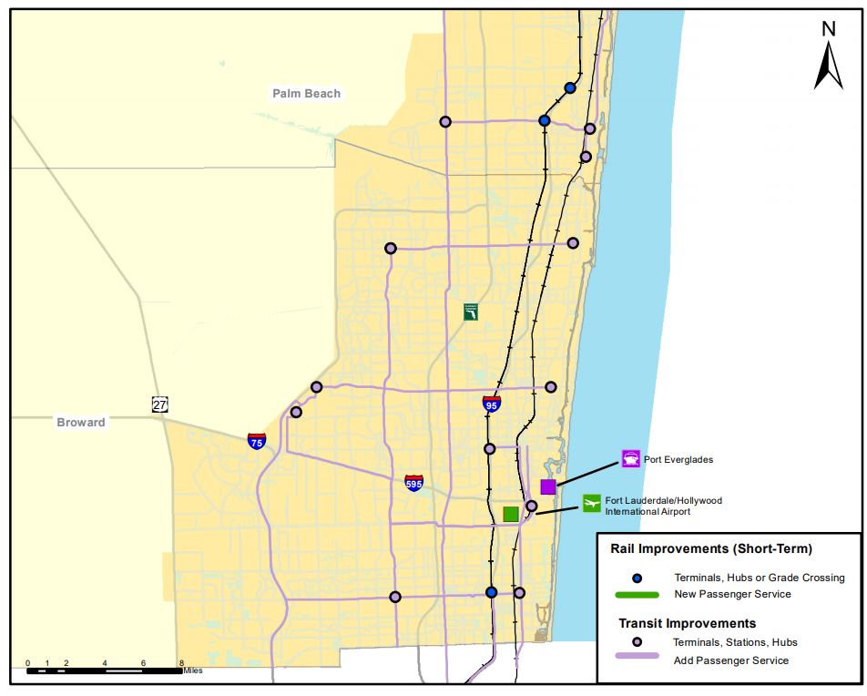
Examples of projects by mode in the 2045 SIS MMUNP released in June 2017 are:
|
This map does not show the multi-county (Miami to Jupiter) Tri-Rail Coastal Link project in the 2045 SIS MMUNP.
FDOT, District 4 identified a deficiency on I-95 in Broward and southern Palm Beach counties but chose not to include a highway project(s) in the 2045 SIS MMUNP to address it, in part to allow time to see what transpires following completion of planned and programmed managed lane and interchange projects on the facility.
The 2045 SIS MMUNP executive summary, technical mapset, and GIS shapefiles are available at http://www.fdot.gov/planning/systems/programs/mspi/plans.
The 2045 SIS Cost Feasible Plan is under development.
BrowardNEXT: Countywide Land Use Plan Update Adopted
The Broward County Board of County Commissioners approved updates to the Broward County Land Use Plan in May 2017, completing Phase 1 of BrowardNEXT, a comprehensive evaluation and update of the County’s land use planning program to meet the challenges of anticipated future growth. The result is a renewed land use planning and policy relationship between the County and its municipalities to better ensure the County's focus on sustainable regional policies and enable municipalities to have appropriate and effective planning tools for the future.
Among the revisions was combining five previous future land use categories (Regional Activity Center, Local Activity Center, Mixed-Use, Transit-Oriented Development, and Transit-Oriented Corridor) into a single Activity Center category, and requiring design guidelines that incorporate pedestrian and bicycle paths and greenways to accomplish fully-connected routes to all destinations within Activity Centers.
Under Phase 2 of BrowardNEXT, the Broward County Comprehensive Plan and the Broward County Land Development Code will be updated.
SFRTA: Transit Oriented Development (TOD) Policy and Outreach Strategy to Complement Tri-Rail and Tri-Rail Coastal Link TOD Planning Activities
At its April 2017 meeting, the SFRTA Board adopted a TOD policy that describes the SFRTA's guiding interest in encouraging station-area TOD and the basic elements needed to create successful TODs. The SFRTA Board also adopted an outreach strategy and has contracted with the SFRPC and the TCRPC to meet with local governments along the South Florida Rail Corridor, on which existing Tri-Rail service operates, to introduce the new policy and discuss their land development regulations relative to TOD. More information is available at http://www.sfrta.fl.gov/transit-oriented-development.aspx.
The SFRTA and two RPCs are also implementing the South Florida Regional TOD Pilot Program using a $1.25 million grant from the Federal Transit Administration (FTA) to conduct TOD planning activities along the Florida East Coast Railway on which future Tri-Rail Coastal Link service would operate. Program activities, which will conclude by June 2018, include charrettes and local government workshops for public input on station location, design, and TOD development elements. The City of Fort Lauderdale also received a $1.25 million FTA grant to, among other things, study TOD for extensions of the Wave Streetcar to other transportation corridors (e.g., in the Uptown area) and, with study partners, catalyze TOD by addressing pedestrian and bike access and connectivity, sustainable urban design, and a variety of housing.
Broward MPO and FDOT: I-95 Integrated Corridor Management
A FHWA grant to the Broward MPO in 2015 led to a partnership that has looked into use of an Integrated Corridor Management (ICM) approach to manage the I-95 corridor as a multimodal system and make operational decisions for the benefit of the corridor as a whole.
The I-95 ICM project will be wrapping up this winter, likely in January or February 2018. Products include a high level concept of operations, functional requirements, and an implementation plan. The Broward MPO will use these products to identify ICM projects for its long range transportation plan. FDOT, District 4 will try to integrate project recommendations into its Transportation System and Operations (TSM&O) master plan. The key project to come from the ICM is the installation of an ICM system, a software system that connects the agencies managing the transportation system and provides performance measures, predicted impacts, and suggestions for improving congestion (in real time).
What's Next?
I-95 CMPP Framework Enhancements
Based on suggestions from the 2016 listening sessions and stakeholder summit, the I-95 CMPP team is developing a process for enhancing the future aspirational transportation and land use vision map, implementation strategies, and performance measures and better integrating them for more seamless implementation into other planning and decision-making processes.
Preliminary concepts for enhancements include:
The Core Group and Working Group for the I-95 CMPP will be convened throughout development of the enhancements to provide needed input. The Core Group is a subset of stakeholders that meet in advance of the Working Group. A series of meetings of both groups are anticipated to be scheduled beginning in Fall 2017. Contact us to be added to the contact list!
Based on suggestions from the 2016 listening sessions and stakeholder summit, the I-95 CMPP team is developing a process for enhancing the future aspirational transportation and land use vision map, implementation strategies, and performance measures and better integrating them for more seamless implementation into other planning and decision-making processes.
Preliminary concepts for enhancements include:
- Developing capstone performance measures based on emerging national research and newly available analysis methods that roll up multiple performance goals into a single measure
- Expanding the set of facility types and place types to better distinguish the differences between multimodal types and set performance targets based on function
- Consolidating and reorganizing the implementation strategies for better integration with the vision map and performance measures
- Evaluating the effectiveness of the strategies using the capstone measures
- Exploring the differences between the adopted future visions and fully aspirational future visions
- Creating an interactive online map that displays the future vision, implementation strategies, and performance results
The Core Group and Working Group for the I-95 CMPP will be convened throughout development of the enhancements to provide needed input. The Core Group is a subset of stakeholders that meet in advance of the Working Group. A series of meetings of both groups are anticipated to be scheduled beginning in Fall 2017. Contact us to be added to the contact list!
|
MPOs to Begin Work on 2045 Long Range Transportation Plans and Regional Transportation Plan
The 2045 transportation planning cycle for Southeast Florida has begun. The Broward and Palm Beach MPOs and the Miami-Dade TPO will develop and adopt 2045 Long Range Transportation Plans (LRTPs) focused on the portions of the Miami Urbanized Area (UA) they serve by 2019. The three M/TPOs, through the Southeast Florida Transportation Council, will develop a tri-county 2045 Regional Transportation Plan as they are developing their 2045 LRTPs. I-95 CMPP stakeholders will have an opportunity to provide input as the plans are developed through their participation on M/TPO committees and other means. |
Broward County Transit to Undertake Major TDP Update
Broward County Transit will begin working on the next major update to its Transit Development Plan (TDP) in early 2018. BCT’s last major update finished in October 2013 and covered Fiscal Years 2014 through 2023. This next major update will cover Fiscal Years 2019 through 2028. BCT prepares annual updates between major updates. For more information on BCT’s TDPs, visit http://www.broward.org/BCT/Reports/Pages/TransitDevelopmentPlan.aspx.
Broward County Transit will begin working on the next major update to its Transit Development Plan (TDP) in early 2018. BCT’s last major update finished in October 2013 and covered Fiscal Years 2014 through 2023. This next major update will cover Fiscal Years 2019 through 2028. BCT prepares annual updates between major updates. For more information on BCT’s TDPs, visit http://www.broward.org/BCT/Reports/Pages/TransitDevelopmentPlan.aspx.
I-95 Express Lanes Phase 3A Under Construction
The extension of I-95 express lanes from Broward Boulevard north to SW 10th Street is under construction and anticipated to be completed in 2020. For more information visit www.95express.com.
The extension of I-95 express lanes from Broward Boulevard north to SW 10th Street is under construction and anticipated to be completed in 2020. For more information visit www.95express.com.
Brightline Coming
Brightline began testing its trains and training crew members in August 2017 for intercity express train services between downtown Miami, Fort Lauderdale, and West Palm Beach anticipated to commence in 2017.
Brightline began testing its trains and training crew members in August 2017 for intercity express train services between downtown Miami, Fort Lauderdale, and West Palm Beach anticipated to commence in 2017.
Project Recognition
I-95 CMPP highlighted in FDOT SIS Policy Plan
One of the new implementation emphasis areas for the Strategic Intermodal System Policy Plan, adopted in March 2016, is SIS coordination with regional and local transportation and land use decisions. The I-95 Corridor Mobility Planning Project is highlighted in the plan as an example of an effort that supports this implementation emphasis area.
I-95 CMPP highlighted in NCTR Report
The Multimodal Transportation Best Practices and Model Element, published by the National Center for Transit Research in June 2014, highlights the I-95 Corridor Mobility Planning Project as a best practice in mapping land uses and transportation, and tying strategies to performance measures based on the functions of transportation facility or place types.
|
